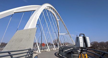
Terrestrial & LiDAR 3D scanning are techniques for collecting high-density spatial imaging with millions of coordinates quickly and accurately.
Using highly accurate 3D scan data generated with 3D scanning you are able to view as-built documentation in a virtual world. The point cloud data can also be surfaced to generate a CAD model which can be used for comparison or reconstruction.
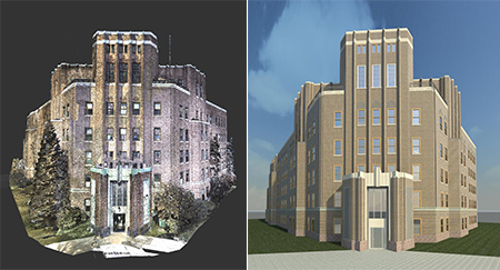
The size of the specimen being scanned is no longer limited to the directional travel of a machine, or the reach of an arm. Scans can be taken anywhere, at virtually any time. The raw output of terrestrial scanning is “point-cloud” data, which we can use as reference to create a fully parametric file in your design software.
3D scanning also helps build a factual and accurate foundation that captures and enhances the necessary dimensions of complex environments and geometries for BIM (Building Information Modeling). Scan to BIM is the fastest, most accurate method for delivering as-built models -there is no comparison on the level and accuracy of data gathered during 3D scanning.
Benefits of 3D Scanning Services:
- On-site 3D scanning of your site that is virtually unlimited in size and environment including broad daylight, the dark of night, indoors, and outdoors
- Receive complete documentation of existing as-built condition
- Obtain permanent records for immediate or future uses
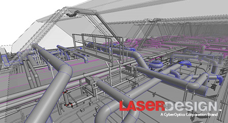
- Our 3D laser scanners collect millions of points to produce a very dense and accurate collection of individual point cloud measurements
- 2D or 3D CAD models can be produced to test and verify design concepts and account for existing conditions
- Provides more accuracy than traditional measured surveys- models include all current building elements such as beams, columns, ceilings, internal walls, external landscape and fittings
- Save time and cost by reducing your time with cameras and measurement devices
- Increase safety in unsafe locations
- 3D Scan and replicate sites and ornate details
- Verify architecture of floors, walls, buildings and more – Terrestrial (or static LiDAR) technology is great for the AEC and AEP world!
3D Scanning Deliverables:
- 3D CAD Models
- BIM Integration
- As-built Documentation
- Fly-through and presentation capabilities with more accuracy than photos or video alone
- Point Cloud Data
- Elevation Drawings
- Plan View Drawings
Why Work with Laser Design on your 3D Scanning project?
- Experienced Technicians – not only does our company have over 30+ years of experience but our technicians are experts in the field.
- Top-of-the-line 3D software systems and software are used on your project! We have experience with the latest technology and always pick the right software and 3D system for your job to ensure the best results.
- ITAR Registered -with Laser Design you know your ITAR project is not only compliant but being fulfilled by a company that is registered.
- We offer comprehensive scanning capabilities- need to capture more intricate details in your large-scale project? We have the tools and know-how to fulfill all your 3D scanning needs.
- Ability to travel anywhere in the world, quickly and with the essential clearances and permits.
- We want to become your 3D scanning partner! Laser Design will guide you through your project whether it’s your first 3D scanning project or you’re an expert in the field.
- And we are price competitive!
The Laser Design team has provided 3D scanning services for clients in many industries around the globe. Our 3D scanning engineers work with you to get you the 3D data you need for your project. Below is a list of some of the projects we’ve worked on out in the field.
| Project | Project Overview | Equipment Used | Software Used | Client |
|---|---|---|---|---|
| MSP Airport, St. Paul, MN | Laser scanned airport mechanical rooms and mechanical bays in the terminal. Created a 3D Revit model of the existing structural features, piping, ducts, equipment and conduit. | Leica P30 and FARO Focus 120 | Leica Cyclone, EdgeWise BIM Suite, Autodesk Recap, Autodesk Revit | Mechanical Design Company |
| World Trade Center, New York City | Laser scanning existing structural features and created a 3D model in Revit. | Faro Focus 120 | Faro Scene, Autodesk Recap, Autodesk Revit | Global Designer and Manufacturer |
| Multiple Silicon Valley Tech Company Buildings, Sunnyvale, CA | Laser scanned the interior and exterior of two 9 story office buildings and mechanical areas. Created a 3D model of all the existing MEP, architectural and structural features including the hangers on all of the MEP. | Two Leica P30/40 and FARO Focus 120/330 | Leica Cyclone, EdgeWise BIM Suite, Autodesk Recap, Autodesk Revit | Construction Company |
| Beverage Manufacturing Plants – Arizona, Wisconsin, Minnesota, Illinois, Florida | Laser scanned multiple assembly lines for design purposes and for the future placement of new assembly lines. Added 3D models of designed assembly lines into the point cloud to verify clearances of proposed equipment to monitor impact on the employees and forklifts. | Leica P30 | Leica Cyclone, Autodesk Recap, Autodesk Autocad | Beverage Manufacturer |